Rouge Park
The Rouge Park Trail is a beginner to intermediate singletrack trail in the City of Detroit’s Rouge Park in the Warrendale neighborhood. Close to Dearborn, Redford, Hines Drive, the Rouge Gateway Trail, Eliza Howell Park, and more. The singletrack is short but has plenty of character and challenge. It basically travels along the banks of the Rouge River from Tireman north to Joy Road, crosses the river, and heads south back to the corner of Spinoza and Tireman. The natural beauty in the middle of an urban area makes this a special place.
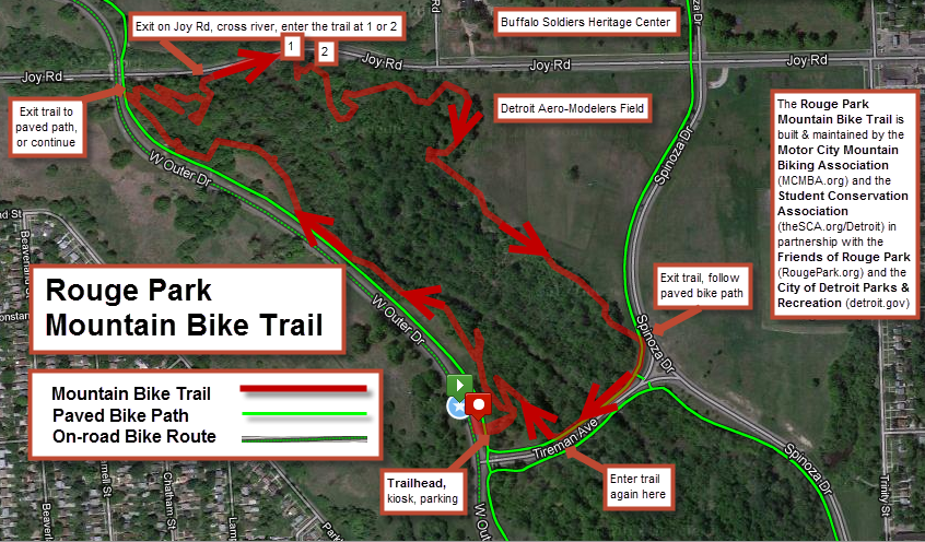
Starting at the trailhead, the trail proceeds clockwise: heading north parallel to Outer Drive with some switchbacks. Near the corner where Outer Drive crosses over Joy Rd, the trail swoops down and heads east towards the river. It exits the forest onto the sidewalk on Joy Rd. Take Joy Rd. east on the bridge over the river, and then jump back into the woods. The trail winds through the forest some more before briefly jumping out into some open space across from the aero-modelers’ field. The trail then winds south following the ridgeline before exiting onto the sidewalk where Spinoza meets Tireman. Follow the sidewalk west on Tireman and jump back into the trail after crossing the bridge over the river. Finish the loop and exit back to trailhead.
Trail Status: open
Trail Miles: 3
Entry Fees: None
Trail Conditions and Discussion Forum: Link
Trail Coordinators: Chris Frey, Peter Croce
Trail Map:Link
Trail runs a clockwise loop within the block bounded by Outer Drive, Joy Rd, Spinoza and Tireman. Trail exits the woods only to cross the Rouge River via the bridges on Joy Rd and Tireman. Follow the wooden arrow signs throughout the trail.
Local Weather: Weather Underground
Directions: Open parking is available along Outer Drive. The Trailhead is the northeast corner of Tireman and Outer Drive. There is a brand new kiosk which will soon hold maps, fliers and other community information.
{google_map}W Outer Drive at Tireman, Detroit, MI 48239|version:new|height:400|width:400{/google_map}